Terry Stokka has lived in Black Forest for 29 years. He is president of the Friends of Black Forest, chairman of the Black Forest Land Use Committee and chairman of the Black Forest Water & Wells Committee.
Editor’s note: The views expressed in the content of this column belong to the writer and not the newspaper or its affiliates.
Mapping The Upper Black Squirrel Creek Aquifer
By Terry Stokka
Upper Black Squirrel Creek begins at the top of the Palmer Divide northeast of the intersection of Shoup Road and Vollmer Road and descends to the southeast, fanning out as wide as Calhan on the east to Falcon on the west and ending in the Arkansas River. Most of the creek is underground but the creek occasionally comes above ground, especially in very wet weather. The creek is what comprises the alluvial aquifer that supplies some of the water to Falcon, Peyton and Calhan, as well as about 3,000 homes on the prairie east of Colorado Springs. The term, alluvial, means that the underground creek is not far from the surface and is moving water as opposed to confined water in the aquifers under it.
Well-drillers in the alluvial aquifer only have to drill wells about 80 to 100 feet deep to get to the water and the water extends to about 180 feet under the ground. This means the layer of water is only about 100 feet thick on average. A positive aspect to this aquifer is that it can be recharged by rain and snow, unlike the Denver Basin aquifers that are much deeper. Unfortunately, dry weather and increasing withdrawals of water are depleting the aquifer faster than it is being recharged. The latest study commissioned by the Upper Black Squirrel Creek Groundwater Management District has found that about 70 of the 100-foot thickness of the aquifer has been withdrawn and there is concern about the future of the aquifer.
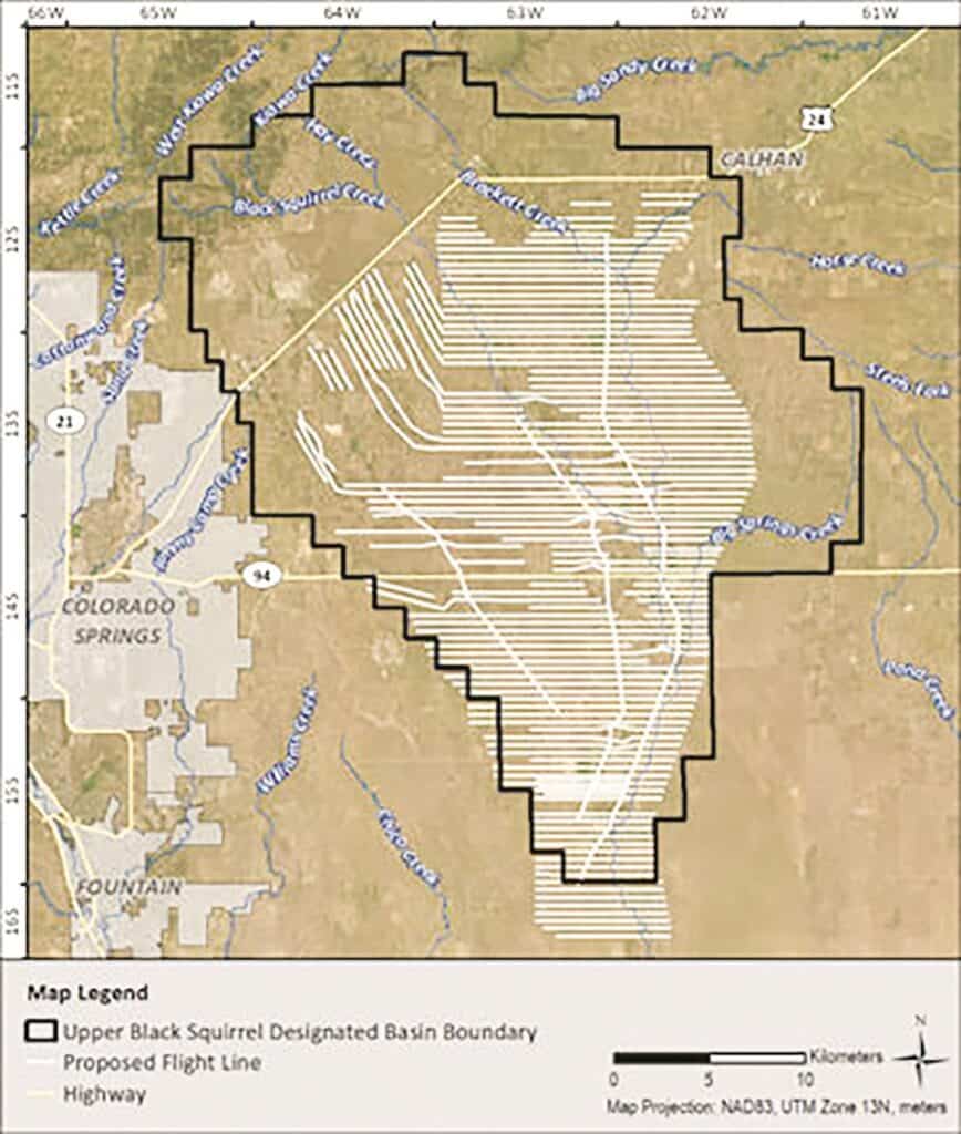
The district contracted with Aqua Geo Frameworks from Wyoming in June 2023 for a unique groundwater study called an airborne electromagnetic survey. AGF operates a helicopter with a metal loop suspended about 40 feet under the helicopter. This loop transmits an electromagnetic pulse downward into the ground and that energy is reflected back in different forms depending on what it hits. Water reflects differently than soil and different soils like clay, gravel or sandstone also reflect differently. The study area measured 13 by 21 miles south and east of Highway 24 from Falcon to Calhan. The helicopter flew back and forth in a precise GPS pattern over the ground with lines about a quarter-mile apart (see picture below). This pattern covered 800 miles of back and forth passes and resulted in a map of the Upper Black Squirrel Creek aquifer. The electromagnetic pulses penetrated the ground as far as 1,200 feet so it showed the water pattern in the alluvial aquifer and also showed portions of the Denver Basin aquifer below it. Aqua Geo also used data from boreholes and wells in the area to crosscheck the data from the helicopter survey.
The resulting report from Aqua Geo Frameworks is 214 pages long and brimming with technical data that is beyond you and me. Dave Doran, president of the district, discussed with me some of the more practical conclusions that we mere mortals can understand and appreciate.
1. The data map shows the depth of the aquifer at any point and the depth of the saturated depth, which is the thickness that is saturated with water. Residents in the study area can input their address into the map on the district website and see this data for their particular location.
2. Geologists have thought the alluvial aquifer had a natural underground “wall” in the southeastern part of the district that formed a dam to hold the water back to some degree. The survey did not find any wall so the alluvial aquifer flows all the way to the Arkansas River.
3. Cherokee Metro District has a wastewater treatment plant southeast of Falcon that releases treated water into the ground to soak back into the aquifer. This water filters through the soil to be naturally cleaned further and will then be pumped up nearer the source of the aquifer in the future to be available for well owners. The survey showed that in the area below the treatment plant the aquifer is thicker because of the treated water released from Cherokee.
The survey enables the district to plan for the future and to know how much conservation must be practiced to keep a supply of water for the future. The district board is confident that they know what is down there and can plan more efficiently. The depletion of the aquifer should make all the district customers more conscious of conservation efforts that must be followed.