By LC Grady
On the morning of June 8, the Upper Black Squirrel Creek Ground Water Management District held a media event at Meadow Lake Airport in Peyton to kick off an aerial aquifer geological study.
The event included a presentation with a question-and-answer session followed by a live equipment demonstration.
Dave Doran, president of the UBSCGW district, a taxpayer funded quasi-government organization that administers and manages ground water resources of the Upper Black Squirrel Creek Groundwater Basin, outlined the overall scope of the project.
The project will map the subsurface and geology of most of the 270 square-mile aquifer in the 354-square-mile Black Squirrel district.
The study, funded by the Upper Black Squirrel district, costs about $400,000 between the mapping flights and the initial preparations. “It’s been a long process involving enormous logistics,” Doran said. “It has taken us about a year-and-a-half since we’ve learned about this technology.”
The preparations included in-depth research by Mike Wireman, the district’s geologist and hydrologist, who among other things researched well locations and logs to confirm what the study’s 3D mapping will show. He closely coordinated with Jared Abraham, a geophysicist from Aqua Geo Frameworks, a Wyoming company conducting the mapping.
Wireman provided a background on the history of the aquifer over the past several decades. “This aquifer was heavily utilized by agriculture in the 40s and 50s, and you used to be able to pump 1,000 gallons a minute,” Wireman said. “Since then, agricultural use declined significantly, and municipal and domestic use have gone up. The amount of water in this aquifer was estimated over time.”
The U.S. Geological Study and the Colorado Geological Study, among others, have completed 15 to 20 reports related to the this aquifer. “What we know is that more than half of the water stored in this aquifer is gone and is not coming back,” Wireman said. The aquifer is around 120 to 200 feet thick; as the water level goes down, the wells produce less. He said the amount of water the well produces is directly related to the thickness of the saturated zone. And in this aquifer, it is less than half of what it was in the 1950s. “The AFG mapping system allows for continuous data between two wells — every 100 feet. Jared’s tool will help us tell the depth of the water,” Wireman said. “Once we know the depth of the water, we will know the saturated thickness, which then can be converted into the volume of the water.”
Wireman also discussed the quality of water in the aquifer. “This aquifer is used not only to take water out but also put water in,” he said. “The water quality … in the alluvial aquifer is relatively pristine.” They have sampled “for anything you can imagine, for all kinds of personal products, drugs, bacteria, metal, you name it,” Wireman said.
“We did a lot of geophysical testing of wells to be sure the mapping program would be successful,” Doran said. “We have had USGS conduct an ongoing water quality study. Water quality, quantity and overall geology all tie together. Taxpayer money is going directly back into these important studies.”
The mechanics of the mapping project
Abraham provided details on the specific operations and mechanics of the study. “Operations will commence in the afternoon after several calibration flights and will last four or five days,” Abraham said. “We are flying a system that carries equipment pulsing the earth, and the pulse that goes into the earth is very low amperage and very specific frequency, interacting with the materials in the earth. Clays and shales versus sands and gravel each conduct frequencies differently.” This system allows them to fly 55 miles per hour with the loop sensor 100 feet off the ground and 100 feet under the helicopter, he said. Nothing is disturbed or destroyed, Abraham said. “We may not fly over anything, where if the load detached, would cause loss of life or damage to property, like over vehicles, houses, herds of animals, etc.,” he said. Helicopters are maneuverable, and the flights operated by Livewire Aviation can only be conducted under visual flight rules, fully cleared through the Federal Aviation Administration. “There are 2,000 wells throughout the district,” Abraham said. “The distance between those wells is from feet to miles. The issue becomes difficult and detailed questions arise about what’s going on in between. That’s where our studies come in.”
Doran said they are going to be the first of the designated basins in the Front Range to conduct this mapping. “I believe this project will be groundbreaking and will help the whole Front Range make better decisions in how we grow, making sure we have enough water to provide for many generations in the future,” Doran said. “We, as a water district, are constantly trying to find tools to give us a better idea of what lies beneath us. There has been extreme population growth in this area, and we are completely groundwater dependent. We need to know how much water is available in this aquifer (underlying the alluvial aquifer are the Denver Basin bedrock aquifers).” He added that they hope to find good water sources and determine the best place to replenish the loss of an “enormous amount of water.”
Who will this study benefit?
“We are trying to get empirical data for the decision makers to be able to draw a conclusive picture and have the best ideas about how to preserve and conserve the aquifer for many generations to come,” Doran said. “The information we will get from the study will be used for the management district, for the state groundwater commission, for county commissioners who approve the development as it comes out and for us to be able to work alongside those other entities to get the best information.” He added that development will have to continue to go east. “There is a smart way to do development, and this tool will help us give better advice on how to continue to grow and utilize resources.”
For more information on the district’s activities, visit https://www.upperblacksquirrelcreekwater.com
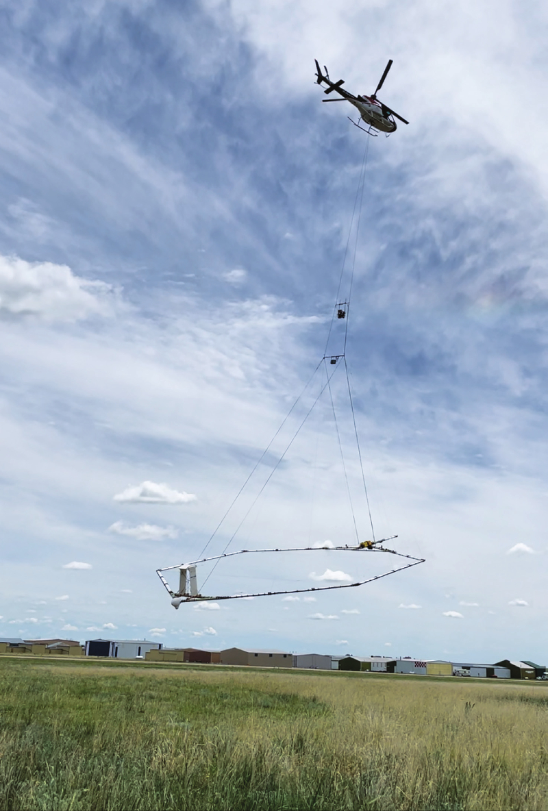
Aquifer mapping: A Livewire Aviation helicopter, specially trained for low-level flying, is taking off with the SkyTEM mapping system.
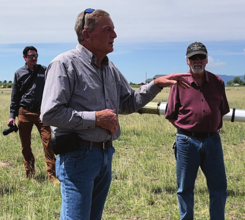
Mapping Doran: Dave Doran, president of the Upper Black Squirrel Creek Ground Water Management District (foreground) and Mike Wireman, the district’s hydrologist, provide information to the media on the Aquifer Mapping Study. In the background, Brandon Forbes, a U.S. Geological Study Associate Director, listens to the presentation.
“We did a lot of geophysical testing of wells to be sure the mapping program would be successful. We have had USGS conduct an ongoing water quality study. Water quality, quantity and overall geology all tie together. Taxpayer money is going directly back into these important studies.”
Dave Doran, president Upper Black Squirrel Creek Ground Water Management District